Information
Radio
P.O.
Box 291918
Kettering , OH 45429
937-299-7226
Donations are most appreciated and can
become a tax deduction for you. Click here to find out more

To Hear Information
Radio Live on your phone, notebook, desktop or laptop computer by clicking on Tunein button below
![]()
or:

Click here to listen to us on our
direct link
Have an announcement that can't wait. Create a 2 minute

Listen here for a live broadcast of Fairmont Firebirds Football
Watch Barney Sentner's preview of the Firebird's next opponent
Watch interviews with this weeks coaches

Information Radio On The Road (Previous
Editions)
Let us help you record your family
history before it is too late!
What is Information Radio?
With
the facilities of Information Radio 1660 government entities and
non-profit organizations can announce at no charge:
![]() 1. Community Events
1. Community Events
![]() 2. List
points of interest
2. List
points of interest
![]() 3. Provide
information on road construction or detours
3. Provide
information on road construction or detours
![]() 4. Promote
any activity open to the general public
4. Promote
any activity open to the general public
![]() 5. Promote
community Garage Sales
5. Promote
community Garage Sales
![]() 6. Promote
other charitable activities and fund raisers.
6. Promote
other charitable activities and fund raisers.
![]() 7. Publicize
theatrical events from professional to community to High School Plays
7. Publicize
theatrical events from professional to community to High School Plays
![]() 8. Use for
Emergency Operations, either weather related or other disaster announcements
8. Use for
Emergency Operations, either weather related or other disaster announcements
![]() 9. Amber
Alerts
9. Amber
Alerts
Information
Radio can be easily heard in the following communities:
![]() Along Interstate 675 at northbound Interstate 75 to its intersection with
Interstate 70
Along Interstate 675 at northbound Interstate 75 to its intersection with
Interstate 70
![]() Along
Interstate 75 at Franklin/Springboro exit to Vandalia
Along
Interstate 75 at Franklin/Springboro exit to Vandalia
![]() Along State
Route 35 from Xenia to Trotwood
Along State
Route 35 from Xenia to Trotwood
![]() Beavercreek
Beavercreek
![]() Bellbrook
Bellbrook
![]() Centerville
Centerville
![]() Kettering
Kettering
![]() Many of the
Five Rivers Metro Parks
Many of the
Five Rivers Metro Parks
![]() Miami
Township (some marginal areas)
Miami
Township (some marginal areas)
![]() Miamisburg
(some marginal areas)
Miamisburg
(some marginal areas)
![]() Moraine
Moraine
![]() Oakwood
Oakwood
![]() Riverside
Riverside
![]() Dayton
Dayton
![]() Sugarcreek
Township
Sugarcreek
Township
![]() West
Carrollton
West
Carrollton
![]() Washington
Township
Washington
Township
![]() Xenia
Xenia
![]() West
Carrollton
West
Carrollton
Since the station is designed as a low power AM station, there will
always be some areas where trolley lines or high-power utility lines may cause
some temporary interference but in the areas listed, the interference caused by
these lines is minimal.
You can also hear us on many devices including:
![]() Your smart
phone
Your smart
phone
![]() Your laptop or
tabletop computer
Your laptop or
tabletop computer
![]() Amazon Echo
Amazon Echo
![]() Google Home
Google Home
![]() Roku
Roku
![]() Tune In
Tune In
![]() Select times
in south Dayton Suburbs on Time Warner Channel 6 or AT&T Channel 99
Select times
in south Dayton Suburbs on Time Warner Channel 6 or AT&T Channel 99
![]() 1660 AM
1660 AM
We can now provide a temporary informational radio
station just for your event. We now have the capabilities of placing an
informational radio station right at your event. You can broadcast information
about your event, parking, directions and much more. This is great for
community festivals, parades and other similar events. Give us a call at 937-299-7226 (Tuesday, Wednesday or Thursday between 11AM and 4PM) and find out how we can help you both promote and manage traffic
for your event with our portable informational radio station.
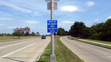
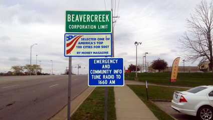
The
stations are promoted through:
![]() Signs
provided by the local communities in the right-of-way
Signs
provided by the local communities in the right-of-way
![]()
Additionally with the
Information Radio facilities long term announcements for local attractions,
such as museums, amusement parks, parks and others can be run on an on-going
basis.
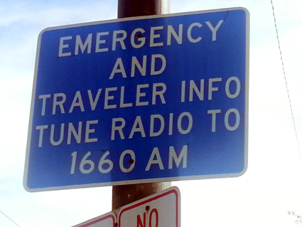
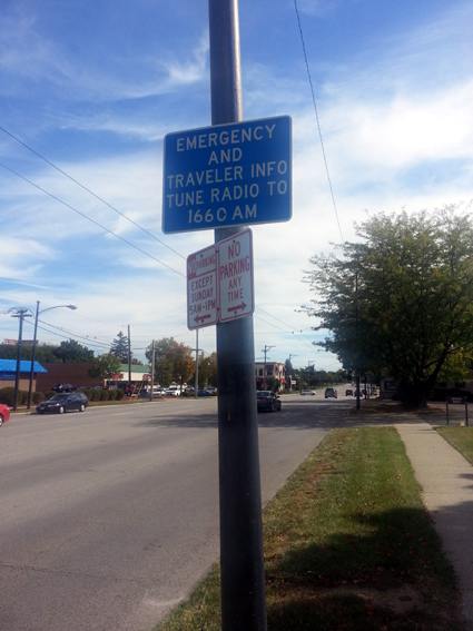
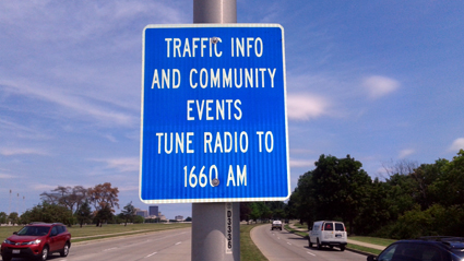
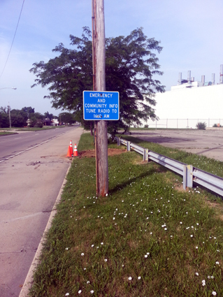
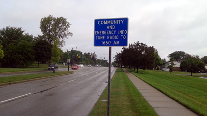
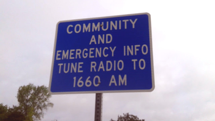
We work with local communities to support Information Radio 1660
with signs posted on local highways and major arteries like this sign in Kettering
on Far Hills Avenue south of Dorothy Lane.
Agencies and
Organizations who have used Information Radio 1660:
![]() American Red Cross
American Red Cross
|
|
![]() Centerville/Washington Twp.
Park District
Centerville/Washington Twp.
Park District
![]() City of
Beavercreek
City of
Beavercreek
![]() City of
Centerville
City of
Centerville
![]() City of
Dayton
City of
Dayton
![]() City of
Kettering
City of
Kettering
![]() City of
Moraine
City of
Moraine
![]() City of
Waynesville
City of
Waynesville
![]() City of West
Carrollton
City of West
Carrollton
![]() Dayton Air
Show
Dayton Air
Show
![]() Dayton
Hamvention
Dayton
Hamvention
![]() Fraze
Pavillion
Fraze
Pavillion
![]() Holiday at
Home
Holiday at
Home
![]() Inventing
Flight Celebration
Inventing
Flight Celebration
![]() Kettering
City Schools
Kettering
City Schools
![]() National Park
Service
National Park
Service
![]() United States
Air Force Museum
United States
Air Force Museum
![]() United States
Marines
United States
Marines
On
going features:
![]() Greeting to area by the Miami Valley's Congressional
Representative
Greeting to area by the Miami Valley's Congressional
Representative
![]() Preparing for
disasters by the American Red Cross
Preparing for
disasters by the American Red Cross
![]() Seasonal
Weather instructions by WDTN Meteorologists
Seasonal
Weather instructions by WDTN Meteorologists
![]() Weather
forecasts by WDTN Meterologists
Weather
forecasts by WDTN Meterologists
For more information on information radio and the specific needs to your
community or organization, contact Norm Schrein at
![]()
![]()
Emergency
Operations:
In case of an on-going emergency, local government agencies can
use the facilities of Information Radio.
![]() 1.
Pre-recorded announcements.
1.
Pre-recorded announcements.
![]() 2. Live
broadcasts.
2. Live
broadcasts.
Weather
Announcements:
In case of the
threat of severe weather (watch or warning) the station will automatically switch
to the National Weather Service Broadcasts and stay on that system until the
watch or warning has been discontinued.
![]()
![]()
More Traffic Signs
Dayton
Sign Locations
Locations:
![]() Northbound
Smithville between southern city limit and Patterson
Northbound
Smithville between southern city limit and Patterson
![]() Northbound
Wilmington between southern city limit and Patterson
Northbound
Wilmington between southern city limit and Patterson
![]() Northbound
South Main Street between southern city limit and
Northbound
South Main Street between southern city limit and
![]() Northbound
Patterson Boulevard just north of Carrillon Park
Northbound
Patterson Boulevard just north of Carrillon Park
![]() U.S. Route 35
east bound just west of Gettysburg Ave.
U.S. Route 35
east bound just west of Gettysburg Ave.
![]() U.S. Route 35
west bound at city limits
U.S. Route 35
west bound at city limits
Signs from City of Dayton on northbound Dixie at the UDRI entrance
Beavercreek
Sign Locations
Locations:
![]() Eastbound
Indian Ripple at Western City Limit
Eastbound
Indian Ripple at Western City Limit
![]() Eastbound
Dayton Xenia Road at Western City Limit
Eastbound
Dayton Xenia Road at Western City Limit
![]() Eastbound
Kemp Road at Western City Limit
Eastbound
Kemp Road at Western City Limit
![]() Southbound
Fairfield at Northern City Limit (Just south of Colonel Glenn)
Southbound
Fairfield at Northern City Limit (Just south of Colonel Glenn)
![]() Westbound
Dayton Xenia just west of Orchard
Westbound
Dayton Xenia just west of Orchard
![]() Westbound
Kemp just west of Beaver Valley
Westbound
Kemp just west of Beaver Valley
![]() Westbound New
Germany Trebine just east of Wyndam
Westbound New
Germany Trebine just east of Wyndam
![]() Westbound
Colonel Glenn at western edge of Wright State Univrsity
Westbound
Colonel Glenn at western edge of Wright State Univrsity
![]() Eastbound
Colonel Glenn just east of Interstate 675
Eastbound
Colonel Glenn just east of Interstate 675
![]() Southbound
National at northern city limits
Southbound
National at northern city limits
Beavercreek's sign on eastbound Indian Ripple at western city limits.
Kettering
Sign Locations
![]() Southbound Stroop
just south of Dorothy Lane
Southbound Stroop
just south of Dorothy Lane
![]() Southbound
Woodman just south of Northern city limit
Southbound
Woodman just south of Northern city limit
![]() Northbound
Woodman just norht of Southern city limit
Northbound
Woodman just norht of Southern city limit
![]() Northbound
Far Hills just north of Rahn Road
Northbound
Far Hills just north of Rahn Road
![]() Southbound
Far Hills just south of Dorothy Lane
Southbound
Far Hills just south of Dorothy Lane
![]() Eastbound
Stroop just east of Dixie
Eastbound
Stroop just east of Dixie
![]() Eastbound
Dorothy Lane just east of Dixie
Eastbound
Dorothy Lane just east of Dixie
![]() Westbound
Dorothy Lane just west of County Line
Westbound
Dorothy Lane just west of County Line
Moraine
Sign Locations
Moraine's signs on northbound Springboro at southern city limits.
![]() End of
Southbound I75 Exit Ramp at Springboro Pike
End of
Southbound I75 Exit Ramp at Springboro Pike
![]() Northbound
Springboro at southern city limits
Northbound
Springboro at southern city limits
![]() Southbound
Dryden Road just north of River Road
Southbound
Dryden Road just north of River Road
![]() Southbound
Dryden Road at Interstate 75
Southbound
Dryden Road at Interstate 75
![]() Southbound
Kettering Blvd. just south of Stroop Road
Southbound
Kettering Blvd. just south of Stroop Road
![]() Eastbound
main street just west of the Government Center
Eastbound
main street just west of the Government Center
Centerville
Sign Locations
Centerville's sign on northbound Main Street just north of Spring Valley
Road
![]() Southbound on
Main Street by Bethany Village
Southbound on
Main Street by Bethany Village
![]() Northbound on
Main street north of Spring Valley Road
Northbound on
Main street north of Spring Valley Road
![]()
![]()
![]()
![]() See a case study on Information Radio
See a case study on Information Radio
![]() Information Radio On The Road
Information Radio On The Road